• Lessons Learned: Hurricanes Laura and Ida

Lessons Learned: Hurricanes Laura and Ida


Preparing for the Future by Understanding the Past

One best practice of hurricane preparedness is to evaluate how your response plan performed during previous hurricanes and tropical storms. This process helps refine your organization's decision-making processes and how you respond to future threats.

Even if your organization wasn't directly impacted by a specific hurricane, there are still lessons to be learned. By understanding the past, we can become better equipped to understand the future.

Read the Lessons Learned from Barry, Harvey, Ida, Irma and Laura.

Hurricane Laura made landfall on August 27, 2020 near Cameron, Louisiana as a Category 4 hurricane. Hurricane Ida made landfall on August 29, 2021 (the 16th anniversary of Hurricane Katrina) near Port Fourchon, Louisiana, also as a Category 4 hurricane.
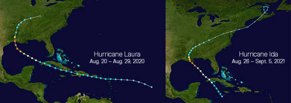
Laura and Ida track maps

Similar Storms, Vastly Different Impacts

Based on their size and intensity Hurricanes Laura and Ida were a perfect match. On StormGeo’s Hurricane Severity Index (HSI) scale, both storms reached 20 points for intensity and 11 points for size (both out of 25) and a max total score of 30 (out of 50). Both storms had Category 4 winds and hurricane-force winds were felt about 50-60 miles from the eye of the storms.


Your business could benefit from StormGeo's Hurricane Forecasting. Let our experts show you how accurate, timely, site-specific forecasts ensure a more effective response to changing weather threats.

Lesson to be Learned

Every storm is unique. Laura and Ida were matched in size and intensity and location, both making U.S. landfall along the Louisiana coast. Yet, the financial losses from Ida were almost four times as costly.

There also was a lot of discussion about the similarities between Hurricane Ida and 2005’s Hurricane Katrina. Ida was on track to make landfall on the anniversary of Katrina. Both storms were major hurricanes and the landfall location for Ida was less than 50 miles to the west of where Katrina made landfall. There were some key differences that changed how the storms impacted Louisiana. Katrina was a much larger storm with a wind field extending 106 miles from the center, compared to Ida’s much smaller wind field of 13 miles. The larger wind field means a higher storm surge and more time exposed to hurricane-force winds.

Everyone knows a major category 3 or higher hurricane isn’t to be messed with. It is the tropical storms or lower category hurricanes where people can be blasé about their preparedness. While all landfalling storms will cause some level of disruption, for every less disruptive tropical storm or category 1 hurricane, there is a Tropical Storm Allison, Tropical Storm Imelda or Hurricane Sally that caused extensive damage despite being a less intense storm.

There are two ways to better plan for these less intense, yet potentially impactful storms.

1. Use more than just wind speeds for your response plan triggers.

StormGeo’s Hurricane Severity Index incorporates wind speeds and the size of the wind field when calculating the damage potential of a storm.

Top 5 Problems with Most Hurricane Response Plans - Misinterpreting Saffir-Simpson. 

See all 5 problems - and their solutions.

2. Incorporate flood risks into response planning.

Understanding your infrastructure risks due to flooding is as important as understanding their susceptibility to high wind speeds. Even if you are far enough inland to be outside a potential surge zone or feel the brunt of the strongest hurricane-force winds, your facilities could still be inundated with freshwater flooding.

170906 miller hurricane irma hero

StormGeo delivers global tropical system updates and business decision guidance for your specific assets.

Interactive tropical storms and hurricane monitoring, tracking and impact analysis. Tropical storms and hurricanes are notoriously difficult to predict.

Hurricane and Typhoon Forecasting